Department of Urban Planning and Settlement Studies Provincial College of Porterville, Year 3015
Abstract
Bravian settlement — whether one is examining a cave-palace provincial capital carved from a mountain, a Middle Bravian market town of thirty thousand souls, a crossroads hamlet of a few dozen houses, a farmstead in an agricultural river valley, or a High Bravian watchtower village clinging to a remote ridge — exhibits a consistency of form, intention, and underlying philosophy that reveals something fundamental about how this nation understands the relationship between people, land, and governance. This paper examines the full spectrum of Bravian settlement patterns from their most concentrated urban expression to their most diffuse rural one, arguing that all of them represent applications of a single coherent planning vision rooted in the covenant framework and the property-rights convictions that animate every other dimension of Bravian civic life. That vision can be stated simply: every piece of connected land is potentially productive, every settled community deserves the full apparatus of self-government and civic life, beauty is a legitimate community goal while luxury is a civic vice, and the plat — the act of marking land into owned and developable lots — is one of the most morally serious acts a community can undertake. The paper surveys each tier of the settlement hierarchy, identifies the planning principles operative at each tier, and demonstrates that these principles form a system rather than a collection of local practices, with the same values expressing themselves differently at each scale without contradicting themselves at any.
I. The Philosophical Foundation: Property, Productivity, and the Sacred Plat
No adequate analysis of Bravian planning can begin anywhere other than the covenant framework and its relationship to land. The principle is direct and has been observed with alarm by every foreign diplomat who has encountered it in practice: “Bravians consider any land that is not platted as being open for settlement. Land that is left open with no improvements made to it, no marking of boundaries or setting up of infrastructure or anything of that nature is considered to be open land that they are free to take and develop for themselves.”
This is not a casual attitude or a convenient rationalization for territorial ambition. It is the planning philosophy made explicit. Land exists to be stewarded, and stewarding land means marking it, owning it, improving it, and making it productive in ways that serve the community it is embedded in. Unplatted land is land that has not yet been brought into the covenant community’s stewardship — land that is still, in the Bravian imagination, waiting to become what it is meant to be. The act of platting is therefore not merely a technical surveying procedure but a covenant act, a declaration that this land now belongs to someone who will be accountable for it, who will build on it or farm it or tend it, and whose ownership of it is a matter of public record and community guarantee.
The romantic weight the Bravians place on this act was captured with some amusement by one foreign observer who was told that a young priest and his new wife spent their honeymoon platting the town where they would serve. The observer thought this sounded decidedly unromantic. The priest’s wife disagreed: “There is little more romantic to a Bravian than seeing empty land become property that can be owned and settled and turned into something productive.” The planning philosophy and the emotional life of the nation are, in this exchange, revealed as the same thing. A plat is a promise — to the land, to the community, and to the future — and Bravians find promises romantic.
The second foundational principle flows from the first: any connected land is potentially profitable. As the priest explained when pressed about Bravian settlement habits, “In Bravia, any land that someone can settle on at all is at least potentially profitable so long as it is connected via a road, a river, or some other form of tie to somewhere else. We focus on internal development and any crossroads, no matter how obscure, has a decent chance of becoming at least a hamlet if not a small town, which means that there are a lot of areas where some sort of trade happens and where a substantial part of the population benefits from property rights and free exchange that is focused on what they want.” This principle — connectivity as the necessary and sufficient condition for economic viability — is the planning logic that drives settlement into terrain that other nations leave empty. It is also why the road and the river are the organizing spines of every scale of Bravian settlement, from the national infrastructure connecting provinces to the footpath connecting a farmstead to its nearest village.
The third foundational principle is the rejection of both extremes of urban social stratification: no slums and no elite districts. The consistent foreign observation of Bravian cities is that “everywhere I have seen in Bravia is a place where comfortable bourgeoisie reside. While there are mild degrees of inequality to be found, and a great deal of variety in the buildings and residences that I have seen, the people of Bravia are remarkably equal across all walks of life. There are no privileged elites whose massive mansions dwarf the more modest homes of their neighbors, no districts of slums where a landless and restive proletariat can be found frustrated by its lack of opportunity.” This is not an accidental outcome. It is the material consequence of a land distribution and property rights philosophy that makes ownership broadly accessible — “a townhouse in the city or a home with a large garden plot just outside of towns or farmland in more rural areas” — and that views the concentration of land in the hands of an elite as a covenant violation rather than as a mark of legitimate success.
These three principles — the sacred plat, connectivity as the condition for productivity, and the rejection of stratified land use — are the foundation on which every scale of Bravian planning rests. They do not produce uniform landscapes; the physical forms of Bravian settlement vary dramatically with terrain, climate, and economic function. But they produce recognizably related landscapes, communities that are visibly the products of the same underlying intention even when they look very different from each other.
II. The Settlement Hierarchy: A Taxonomy of Bravian Urban Forms
Bravian settlement exists in a recognizable hierarchy of forms, each with distinct functions, governance requirements, and physical characteristics, each growing organically from the one below it when conditions support growth. Understanding the hierarchy is prerequisite to understanding how the planning vision applies at each tier.
At the base is the trading post, typically the first human institution to appear in a new territory. The trading post may consist of no more than a dock or landing, a warehouse, a small inn, and the modest homes of the merchants and workers who operate it. It may or may not be large enough to qualify as an Amphoe in its own right, but it serves as the commercial anchor around which further settlement organizes. The trading posts across the Southern Sea, on the Western River, and on the coasts of foreign nations all represent this earliest tier — Bravian commercial presence that may or may not mature into full settled community depending on what opportunities the surrounding territory presents.
From a crossroads or a trading post that draws enough passing traffic, a hamlet forms — what one foreign observer described with evident disdain as “a miserable set of rather unimpressive houses” but which, in the Bravian understanding, represents a community serious enough to send a representative to the Grand Parliament and be treated as a meaningful political entity. Hurrendale, the hamlet encountered during one diplomatic journey through North Bravia’s rougher territories, was described as having been “presumably” named “after the poor sod of a settler who had established this place as a hamlet connecting some rough roads together in such a manner as to make this area a rural crossroads” — and it was, naturally, also an Amphoe, “meaning that the people of this miserable set of rather unimpressive houses sent someone to the Grand Parliament who voted on the most important affairs of state and was treated as a noteworthy person.” The foreign observer’s sarcasm is precisely where the Bravian and the outsider worldviews most sharply diverge. A hamlet is not a failed town. It is an early town, with everything a town needs except more people and more time.
The village and the borough represent intermediate scales between the hamlet and the full Amphoe town, distinguished primarily by population and service capacity. As a community grows from a hamlet, the services it can support grow with it — a church with a full-time priest rather than a visiting one, a grange facility, a school, a wider range of trades and shops, and eventually the full apparatus of Amphoe self-government with its covenant framework, elected governing body, and Grand Parliament representation. The growth is organic: as “word goes out about what sort of people are needed in an area,” those with the required skills migrate in, filling gaps in the community’s economic life and accelerating its development toward the next tier.
The Amphoe city — the fully developed district capital — is the civic ideal of the Bravian planning vision made real. It provides “a full range of services to its citizens and the surrounding area.” It has its own covenant framework, its elected governing body, its religious congregation with a settled priestly establishment, its grange, its school, its commercial district. Its downtown is near a water feature — a river, a lake, a harbor — because water historically anchored commerce and because the Bravian town’s orientation toward productive land use is expressed in its siting as much as in its layout. Its streets form a rectangular grid with east-west named streets sharing names with the mother city’s corresponding streets, and north-south numbered roads running from the downtown. It is built in the solid, plain, comfortable construction that is the material expression of the bourgeois-equality planning philosophy: no luxury, but genuine quality; no ornament for its own sake, but built to last and to serve.
The provincial capital is a distinct category that will receive extended treatment in Section IV, as it follows a formula sufficiently specific and demanding as to constitute its own planning typology.
III. The Amphoe City: Layout, Aesthetics, and the Bourgeois Ideal
The Amphoe city is where the Bravian planning vision is most completely realized and most consistently expressed across the national landscape. Porterville and New Porterville, described in detail by a foreign visitor, represent this tier in its most fully documented form, and they exhibit the characteristics that, from all available evidence, can be taken as typical of Bravian Amphoe cities generally.
The rectangular grid is the organizing principle of the Bravian urban plan, and its orientation is not arbitrary. East-west streets bear names; north-south roads bear numbers counting outward from downtown. This convention, consistent enough across the country that both Porterville and New Porterville share street names inherited from the same mother-city naming tradition, provides a navigational logic that any Bravian traveler can use in any Bravian city without learning the local geography from scratch. A visitor from Porterville arriving in a city two provinces away will find the same organizational system: named streets running one direction, numbered roads the other, downtown near water. The specific names and the specific water feature will differ; the logic will not.
The downtown’s orientation toward water reflects a planning wisdom that predates Bravian settlement of their current territory but has been consistently applied here: water is where commerce concentrates, where goods transfer between modes of transport, where the fishing fleet lands its catch and the grain barge loads its cargo. A downtown near water is a downtown that earns its position by serving the economic life of its region rather than by claiming territory for prestige reasons. When Porterville’s downtown faces the Eastern River and New Porterville’s faces the same river from the opposite bank, with the road and rail bridges connecting the two downtown cores closely, this is not coincidence but planning intention expressed at both the individual city level and the regional level simultaneously.
The consistent quality of construction throughout Bravian Amphoe cities — “a pleasant and solid Middle Bravian construction” — is the material expression of the no-slums, no-elite-districts principle. Foreign observers are invariably struck by this, because it violates their expectation that urban space will be stratified: that the wealthy will cluster in visible districts of large and impressive homes, and that the poor will cluster in visible districts of degraded and overcrowded ones. Bravian cities contain neither. The homes of the more and less prosperous differ in size and amenity but not in basic quality of construction, and they are not segregated by district in ways that make poverty or wealth geographically legible to a visitor. The Amphoe city looks, throughout its neighborhoods, like a city built by and for people who expect to own what they live in and who expect their ownership to be respected by their neighbors and their government.
Beauty is valued and present. Religious buildings, grange halls, civic assembly spaces, and public gathering areas are built with care and with attention to aesthetic quality. But the distinction between beauty and luxury is enforced by covenant and by culture: luxury means spending beyond what serves a genuine function, using display to establish hierarchy rather than quality to serve need. A beautiful church with fine proportions, honest materials, and skilled craftsmanship is the Bravian architectural ideal. A church covered in gilded ornament to demonstrate the wealth and status of its congregation is a covenant violation dressed in stone and gold. The tithe funds “things that serve to spread the faith either in geographic spread or in depth. Education efforts are celebrated, as it helps people to understand the Bible and their own obligations more, but mere show is frowned on, as it is a sign of waste and corruption.”
This aesthetic philosophy produces cities that strike most foreign visitors as pleasant and well-kept but somehow austere — lacking the grand gestures that signal civic pride in most nations. The Bravian understanding of civic pride runs differently: it is expressed not in monuments to the city’s greatness but in the quality of the road surfaces, the maintenance of the public spaces, the accessibility of the grange and the school, and the absence of the degraded districts that in most cities mark where civic pride has given up.
IV. The Provincial Capital: The Covenant Formula in Architectural Form
The provincial capital is the point at which Bravian planning achieves its most formally specified and most architecturally distinctive expression. It is not simply a large city with a governmental function; it is a precisely specified compound of elements, each of which carries theological and constitutional meaning, whose assembly in the correct relationship to each other is a requirement rather than a preference. The formula was stated with clarity by the Governor of the Over-The-Eastern-River Province in response to a diplomatic visitor’s question about why the provincial capital’s cave palace resembled so closely the national capital’s:
“There are certain mountains — none of which can be active volcanoes or as active sites for mining minerals — which can serve as places for cave palaces. All must have heights near the cave palaces that can serve as places for temples that are built as replicas of the one in the capital, and all must have level places nearby that can serve as places for provincial assemblies that act as local Parliaments in the same way that the Grand Parliament exists in the capital. These elements must all be found relatively close to each other, to create the whole capital compound as well, which also requires nearby fortifications which serve to protect the capital region as a whole as well as a trading post that allows for goods and services and people to travel easily to the region but not to the capital itself, which requires more effort.”
The formula contains six required elements, each with planning implications: the qualifying mountain (stable, non-volcanic, non-mineral-active), the cave palace within it, the heights above for the temple replica, the level plateau for the provincial assembly, nearby fortifications for the capital compound’s defense, and the adjacent trading post as the commercial and logistical anchor. These six elements must be found in natural proximity to each other, which is why the search for a provincial capital site begins with a survey of the provincial geography to find where these conditions coexist — and which is why the provincial capital of the Over-The-Eastern-River Province was located “only on the far Eastern edge of the province,” far from most of the population, because that was where “the necessary mountains and other high places where capitals could be made” happened to be.
The theological content of this formula is not incidental. The cave palace expresses the Exilarchic theology of humble governance: “There is something humble about the way that a ruler in peacetime is supposed to enter his capital on a donkey, just like our Lord and Savior entered Jerusalem on a donkey when He was proclaimed as the Son of David before his crucifixion.” A palace dug into a mountain, accessible only by a donkey path, is architecturally incapable of projecting the kind of intimidating grandeur that most governments use to communicate their power over their subjects. The governor does not live in a structure designed to overawe; he lives in a structure designed to serve, concealed in the mountain it is part of rather than dominating the landscape from a hilltop. The inaccessibility of the donkey path is not merely a security measure; it is a statement about the relationship between ruler and ruled that is built into the very approach geometry of the building.
The temple heights above the cave palace reverse the relationship between secular and sacred governance that most architectural traditions embody. In most cities, the governmental building is the most prominent structure, with religious buildings appropriately subordinate in scale and visibility. In Bravian provincial capitals, the religious heights — temple replicas of the national temple — sit above the cave palace, visible from the plateau where the provincial assembly meets. The political authority of the governor is physically located below the religious authority of the covenant community’s worship. The assembly plateau between them is where the two meet: the people’s representatives deliberating on the plateau that sits between the temple heights above and the governing executive below, accountable to both.
The national capital, which “simultaneously serves as the capital of Northern and Middle Bravia, as it straddles the boundary between them,” expresses the same formula in its original and most refined form. The Grand Parliament meets “in a large open area that sat on a plateau below the Templo Mayor as well as the mountain fastness where the Exilarch had his cave-fortress.” The residential and commercial district “Port Royal, is made up of a bunch of low-buildings and wharves that sits on the shores of a nearby lake” — the trading post function, at the national scale, is Port Royal, functioning as the commercial and residential support zone for the capital complex proper. The six-element formula is not a later imposition on existing capital patterns; it is the original pattern from which all provincial replication flows.
The planning implications of this formula for provincial capital siting are substantial. It means that provincial capitals cannot be located wherever would be most convenient for the population they serve. They must be located where the geology and topography permit the formula’s requirements to be met. The governor of the Over-The-Eastern-River Province acknowledged this directly: the capital is “a long way from the other settlements that were being established in the province,” because the qualifying mountain was at the eastern edge of the province rather than the center. Roads will eventually be built to connect the population to the government, but the government’s location was fixed first by formula and only then connected to the population by infrastructure.
This is a planning philosophy that subordinates administrative convenience to theological and constitutional principle — and it produces capitals that look alike across the national landscape not because of aesthetic conformity imposed from above but because the same formula applied to different mountains in different provinces produces recognizably similar results.
V. Suburban Form: The Settlement Ring and Its Economy
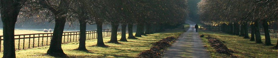
Between the Amphoe city’s downtown and the agricultural hinterland stretches a settlement ring that, in the Bravian pattern, serves functions that in other national traditions would be divided between suburbs, market gardens, and rural villages. The Bravian pattern collapses these into a continuous zone that moves from residential with garden plots, through mixed residential and horticultural, into small-scale farming, without sharp transitions between them.
The key feature of this zone is the garden plot — a piece of land immediately outside the town proper, large enough for a family to grow a meaningful portion of its own food without being so large as to constitute a full farm operation. “A townhouse in the city or a home with a large garden plot just outside of towns or farmland in more rural areas” is the sequence of residential land types described by observers of Bravian settlement, and it is a sequence that reflects a covenant philosophy of stewardship applied at every scale. The household with a garden plot is not simply a family with a hobby; it is a household exercising the stewardship of a piece of the created order, producing food from soil that they own and tend, extending the productivity of the land directly into their domestic economy.
This pattern resists the sharp urban-suburban boundary that characterizes most planned settlements, where a defined edge separates the dense urban fabric from the less-dense residential zone beyond. Bravian settlement tends instead toward gradual density transition — more lots per acre near downtown, fewer per acre as one moves outward, with the lot sizes increasing to accommodate larger garden plots and eventually transitioning into outright farmsteads without a clear dividing line. The roads of the grid system extend outward from downtown until they reach terrain or land use that makes the grid impractical, and the numbered-roads system provides navigational continuity across the transition from urban core to suburban fringe without requiring a new naming convention.
The commercial function of the suburban ring is not merely residential support. As settlements grow and the frontier moves further away, the staging and provisioning economy that characterized the first generation of a new Amphoe — the off-road vehicle suppliers, the modular building factories, the construction supply businesses of New Porterville — gives way to a more settled economy of trades, crafts, and services oriented toward the mature community around them. The suburban ring in a mature Bravian Amphoe contains the light industry and skilled trades that serve both the agricultural hinterland and the urban core: the blacksmith, the carpenter, the miller, the wagon-maker, the provisioner who supplies both the town market and the farms beyond it.
What is consistently absent from the Bravian suburban ring is the category of land that most nations reserve for the prestige residences of the wealthy. Because Bravian planning philosophy rejects elite architecture as a legitimate land use, the large estate with its ornamental grounds and its deliberate demonstration of exclusivity simply does not appear. Prosperous Bravian families live in larger and better-appointed versions of the same solid bourgeois construction that their neighbors inhabit; they do not live in a qualitatively different category of structure designed to communicate their social distance from those neighbors. The land that in other nations would be consumed by aristocratic estates is in Bravia available for the garden plots and small farms of ordinary households.
VI. Rural Form: Farms, Hamlets, and the Road as Organizing Spine
The Bravian rural landscape is organized, at its most fundamental level, by the road and the river. These are the connective tissue that makes the priest’s principle operative — that any connected land is potentially profitable — and their presence or absence is the primary determinant of where rural settlement forms and how dense it becomes.
The family farm is the basic rural unit. Farmsteads are located on the land they work, close enough to a road or river to participate in the market economy but far enough from the town center to have the agricultural space required for productive operation. The farmstead typically includes the primary dwelling, agricultural outbuildings, and whatever small-scale processing facilities — a cider press, a smokehouse, a root cellar — the family’s operation requires. It is not grandiose; the same aesthetic philosophy that governs the urban built environment governs the rural one. But it is solid, built to last through a generation of hard weather and hard work, and it is the family’s own in a way that is legally guaranteed and culturally fundamental.
Around every crossroads in the agricultural zone, at every point where two roads meet or a road reaches a river crossing, the hamlet arises. Hurrendale, encountered on a rough diplomatic journey through North Bravia’s less-developed territory, illustrates this pattern in its least polished form: named after its founding family, built at “a rural crossroads,” consisting of “a miserable set of rather unimpressive houses” with a restaurant-inn serving the passing traffic, qualified as an Amphoe and represented in the Grand Parliament. The deliberate elevation of the crossroads hamlet to political significance — one vote in the Grand Parliament, regardless of size — is the governance expression of the same planning philosophy that says any connected land is potentially productive. Any community, however small, deserves the apparatus of self-government and political voice that the Bravian covenant framework provides.
The development trajectory of the hamlet is visible in the contrast between Hurrendale — apparently stuck at an early stage because of strategic decisions about road quality, which the prince explained the Crown Prince of Bravia as royal governor had chosen to keep rough as long as the area’s backwardness served defense purposes — and communities like the forest-edge trading town encountered on the same journey, which had grown to something clearly larger, with “well-maintained” city streets, a substantial open town-meeting space, and “particularly nice looking builds” serving religious and civic functions. The difference between the two is not of kind but of development stage: one is a hamlet waiting for the conditions that will allow it to grow, the other has already grown through several stages of the hierarchy.
The rural road network is a planning system as much as a transportation system. Roads are not built simply to connect existing settlements; they are built to create the connectivity that allows new settlements to form. As the governor of the Over-The-Eastern-River Province described his plans for developing the new province: “We hope as well that along the main rivers that feed into the Eastern River in the province that many Amphoe will be built that are all connected to each other by river and by land that allow for transportation and infrastructure to be built in a reasonable fashion.” The road and the river are planned first; the settlements along them follow. This is the reverse of the approach most nations take, where roads are built to connect existing population centers. Bravian rural planning builds roads to create the conditions for population centers to form.
The rural areas also serve the hunting, logging, and fishing economies that coexist with agriculture in many Bravian provinces. Hunting and logging camps represent the most diffuse form of Bravian settlement — temporary or semi-permanent encampments that serve extractive industries without aspiring to the full civic apparatus of a hamlet. Fishing docks along navigable rivers and coastal areas are similarly specialized, serving a population that may live in an adjacent hamlet or village rather than at the dock itself. These specialized rural forms are understood within the planning framework as legitimate and productive uses of land that contribute to the community’s economic life without requiring the full settlement hierarchy’s infrastructure.
VII. High Bravian Settlement: The Mountain Tier and Its Strategic Function
The mountain landscape of Bravia is settled in a pattern entirely distinct from the lowland agricultural and riverine pattern, by a population — the High Bravians — whose culture, economy, and relationship to the land reflect the particular demands and possibilities of high-altitude terrain. Understanding High Bravian settlement is essential to understanding the Bravian planning system as a whole, because the mountain tier performs functions for the national system that no other tier can perform.
High Bravians are described as “largely materially poor, extremely independent-minded, and very proud, to the point where their dwelling in largely remote and rural villages in the valleys or on the sides of daunting mountains working in mining or herding or high-altitude farming or the rudiments of trade in what passes for towns in these parts” is entirely characteristic of their way of life. Their settlements are small, their roads are poor by national standards, and their integration into the lowland economy is limited by terrain. But their settlement pattern is not the result of poverty or failure. It is deliberate.
The Governor of the Over-The-Eastern-River Province was explicit: “Wherever there are mountains that do not have any other settlements on them, High Bravians will set up new villages wherever they can be made. Our cave palaces are only the internal living in the mountains that Bravians do. Many of us as Bravians are descended from the people of High Bravia, who are always most comfortable in hilly areas or even in mountainous areas or high plateaus. Such area cannot support a high population density, and for security purposes it is best for their villages and watchposts and fortresses to extend across entire ranges wherever they may be found, so they can serve as the gatekeepers for the provinces and for the nation as a whole.”
The High Bravian settlement pattern is therefore not a residential pattern that happens to have security implications; it is a settlement-as-security-infrastructure pattern in which the inhabitation of the mountains is itself the defensive system. The villages, watchposts, and fortresses extend not just through organized provincial territory but beyond it — High Bravians settle “mountain fastnesses that were far beyond our understanding and recognition, looking at our cities and communities and keeping track of our behavior and communicating it up and down the mountain ranges.” This distributed human intelligence and early warning network, sustained by ordinary residential occupation of the mountain terrain, is something no conventional military installation could replicate at equivalent cost or with equivalent resilience.
The High Bravian farmhouse-fortress is the architectural expression of this dual function. One diplomatic observer reported being told “that there are farmhouses here that double as fortresses,” and the observation was accepted matter-of-factly: of course. A farmhouse in High Bravian mountain territory serves both as a residence and as a defensible position, with the same building performing both functions through design rather than through the costly and conspicuous construction of separate military facilities. The farmhouse-fortress is the domestic architecture of a people who have internalized the understanding that civilian habitation of strategic terrain is itself a form of strategic commitment, and who have built their homes accordingly.
The High Bravian mountain economy is organized around mining, herding, and high-altitude farming — activities that can sustain small communities in terrain that would be economically marginal under any other production system. The diversity of these activities means that different mountain communities specialize in different products, creating a limited but real mountain-to-lowland trade economy in which the High Bravian settlements exchange their distinctive products — metals, livestock, high-altitude crops, timber from mountain forests — for the lowland agricultural and manufactured goods they cannot produce efficiently in their terrain.
The small towns of the mountain zone follow the same general organizational principles as lowland hamlets and villages — rectangular grids where the terrain permits, downtown near whatever water feature is available, Amphoe governance for qualifying communities — but with adaptations to their circumstances. Mountain terrain rarely permits the regular grid of a river-valley town; the roads follow the contours available rather than an idealized plan, and the building footprints fit the ledges and slopes available rather than standardized lots. The planning principles are applied with the terrain rather than imposed upon it.
VIII. The Fremen Delta Settlements: Adapting the System to Swamp and Water
The founding of the Delta Province and the settlement of the Fremen people within it represents the most recent and most geographically distinctive application of Bravian planning principles to a radically different landscape. The delta’s swampy, canal-threaded, tide-influenced terrain shares almost nothing with the river-valley agricultural landscape of Middle Bravia or the mountain terrain of the High Bravians. Yet the same planning principles were applied, adapted to what the terrain offers.
The Fremen’s own settlement traditions — built around “distinctive flat-bottomed boats” suited to shallow-water navigation, around a rice-paddy and fishing economy shaped by delta hydrology — informed the planning of the initial six Amphoe, each of which was “platted” in advance by the Bravian government before the Fremen arrived, with “initial places where your people could immediately build their first houses upon arrival in towns that were already platted” and “plots for farming to take place when they arrive.” The Secretary of the Interior’s approach — six smaller towns, each platted with surrounding farmland — is the standard Bravian settlement formula applied to a new landscape with new farmers: the grid, the central settlement, the surrounding agricultural plots, the expectation of organic growth through natural increase and targeted migration as word spreads about what skills are needed.
The Fremen’s flat-bottomed boat culture fits naturally into the delta’s water-road system. Where the Middle Bravian settlement relies on the road and the river as connective tissue, the Delta Province settlement relies on the canal, the distributary channel, and the tidal waterway as the equivalent connective tissue. The planning principle — any connected land is potentially profitable — applies identically; what counts as connected is defined by the hydrological network rather than the road network. A hamlet at the junction of two channels in the delta is the functional equivalent of Hurrendale at the junction of two clay roads in North Bravia.
IX. The Free Port: The Deliberate Exception
The Free Port of Bravia occupies a unique position in the Bravian planning landscape precisely because it is explicitly not organized on Bravian planning principles. It is “an autonomous zone within the much larger nation of Bravia, under its protection but free to adopt its own ways within its very confined territory.” Its landscape — “its massive central business district spreading out in a narrow area near the shore” — is the antithesis of the bourgeois-uniformity planning philosophy that governs every other Bravian settlement. It is the place where the luxury, the display, the concentrated commercial intensity, and the cosmopolitan social stratification that Bravian covenant culture explicitly rejects are permitted to exist because the Free Port’s commercial function requires them.
The Free Port is mentioned here not to analyze its own planning but to clarify by contrast what the rest of the Bravian planning system is doing. The existence of the Free Port as a deliberate exception — maintained with clear eyes about what it is and why it serves a purpose that Bravian-governed territory cannot serve — illuminates the intentionality of the planning philosophy elsewhere. The Bravians could have adopted Free Port-style commercial urbanism throughout their territory. They chose not to. The planning principles examined in this paper are not the result of underdevelopment or incapacity; they are the result of deliberate philosophical commitment expressed consistently across every scale of the settlement system.
X. The Planning System as a Whole: Cross-Cutting Principles
Having surveyed each tier of the settlement hierarchy, it is possible to identify the cross-cutting principles that hold the system together and that make it genuinely a system rather than a collection of local practices.
The first is the internal development focus. Bravian planning does not create showcase cities at the expense of the hinterland. Resources flow into infrastructure — roads, bridges, rail — that connect every tier of the settlement hierarchy to every other, because the connectivity principle demands that any connected land be provided with the connections that make it productive. The result is a national landscape in which there are no dramatic inequalities between the development levels of different regions, only temporal differences between areas that have been settled longer and areas that have been settled more recently.
The second is the no-idle-land principle. Unplatted land is open land; open land is land waiting to be settled. This creates a powerful and continuous pressure against land speculation — the holding of land without improvement in anticipation of a price rise. A landowner who holds land idle invites its settlement by others. This is not a punitive enforcement mechanism but a cultural expectation backed by the foundational understanding of property rights: property exists to be stewarded, not hoarded. The Bravian land market is therefore characterized by active development rather than speculative holding.
The third is the mother-city law and the settlement group. New settlements are founded not by individuals striking out alone but by groups capable of staffing all the essential functions of a viable community from the moment of their arrival. The mother-city law, adopted as the baseline covenant for the new settlement and then amended as local conditions require, means that new communities begin with a proven legal framework and diverge from it as their specific circumstances demand. This produces the family resemblance between all Bravian settlements — they look and feel like variations on a theme because they are — while still allowing each community to develop its own particular character over time.
The fourth is the beauty without luxury principle. This is the aesthetic standard applied consistently from the most remote High Bravian farmhouse to the provincial capital’s cave palace. Buildings are built well, maintained carefully, and designed with attention to proportion and craft. They are not decorated with ornament whose only purpose is to advertise the owner’s wealth or the institution’s prestige. The standard is the same across all social classes and all settlement tiers, which is why a foreign visitor moving through Bravia finds the built environment surprisingly uniform in quality — not because there is a single building style, but because there is a single quality standard that applies everywhere.
The fifth is the strategic integration of settlement and security. The High Bravian mountain settlement pattern, the farmhouse-fortresses, the deliberately kept-rough roads in strategically sensitive border areas, the cave-palace capitals accessible only by donkey path — all of these represent the integration of settlement planning and military-strategic planning into a single system. Settlement decisions are informed by security requirements; security requirements are met through settlement patterns rather than through separate military infrastructure. This produces a national landscape in which the civilian settlement is itself the first line of defense, a quality that no invading force has yet successfully countered.
XI. The Planning Philosophy and Its Social Consequences
The planning principles described in this paper are not neutral technical choices. They produce a particular kind of social landscape and a particular kind of social experience, and these consequences are at least as important as the physical forms they generate.
The most significant social consequence is the broad distribution of property ownership and its effects on civic participation and social cohesion. When virtually every family owns the land it lives on and works — whether that is a townhouse lot in an Amphoe city, a home with a garden plot on the urban fringe, or a farmstead in the agricultural hinterland — the entire population has a direct material stake in the stability and good governance of the community. The property owner has something to defend, something to improve, something to bequeath to children. This creates the social foundation for the kind of sustained civic engagement that the Bravian covenant framework demands: people who are invested in the outcome of governance are people who will participate in governance, attend the assembly, vote in the referendum, and hold their representatives accountable.
The no-slums, no-elite-districts principle has an equally significant social consequence: it makes social class illegible from the built environment. A foreign visitor cannot identify the wealthy districts and the poor districts of a Bravian city, because they do not exist as distinct districts. This does not mean there is no economic inequality; it means the inequality is not embedded in the landscape in ways that reinforce and perpetuate it. The child who grows up in a Bravian city does not grow up in a neighborhood that tells her, every day, that she is at the bottom of a hierarchy from which escape is unlikely. The planning philosophy actively prevents the kind of spatial stratification that in most nations reproduces social stratification generation after generation.
The settlement hierarchy’s political implications reinforce these social consequences. Every qualifying community — down to the crossroads hamlet that qualifies as an Amphoe — sends a representative to the Grand Parliament with exactly one vote, equal to the vote of the largest and most prosperous Amphoe city in the country. This means that the planning principle of treating every connected piece of land as potentially productive is directly reflected in the governance principle of treating every qualifying community as politically equal. The hamlet and the city are different in scale but identical in standing before the covenant community’s law.
XII. Conclusion: The Plat as Covenant
The Bravian planning system, viewed across all its scales and all its forms, is most accurately understood not as a technical discipline — a set of rules about lot sizes and road widths — but as the spatial expression of the covenant philosophy that organizes every dimension of Bravian life. The plat is a covenant act. The road that connects a new settlement to the market is a covenant obligation fulfilled. The farmhouse built to last is a covenant commitment to the stewardship of the land. The hamlet that receives Amphoe status and Grand Parliament representation is the covenant community recognizing that every community of a certain scale deserves full participation in the common life of the nation.
The consistency of the planning vision across the full spectrum from cave-palace provincial capital to High Bravian watchpost village to Fremen delta hamlet is therefore not the result of centralized planning authority imposing uniform standards on diverse communities. There is no Bravian Ministry of Urban Planning issuing design standards to every settlement in the nation. The consistency is the result of a shared philosophical framework — the same understanding of property, of productivity, of beauty, of stewardship, and of community — that each community applies independently in its own circumstances and that produces recognizably related results everywhere it is applied.
The priest in New Porterville was right that there is something romantic about platting a town. The romance is not in the surveying equipment or the lot stakes. It is in the act of covenant: marking this land as ours, committing to steward it well, promising to build on it something that serves the people who will live there and the God who gave it to them. Every Bravian settlement, at every scale, from the mountain cave-palace to the crossroads hamlet, is that promise made in wood and stone and road and river and plat.
The author acknowledges that this paper, written in Porterville and drawing substantially on the experience of the Porterville–New Porterville metropolitan area, represents a Middle Bravian perspective on planning principles that are applied differently in the mountain communities of High Bravia, the delta settlements of the Fremen, and the forest-edge hybrid communities of the Northern provinces. A full accounting of regional variation in the application of these principles, including the influence of Forester settlement patterns and the specialized needs of the Free Port’s adjacent communities, awaits future scholarship.
